Lorem ipsum dolor sit amet, consectetur adipiscing elit. Ut elit tellus, luctus nec ullamcorper mattis, pulvinar dapibus leo.
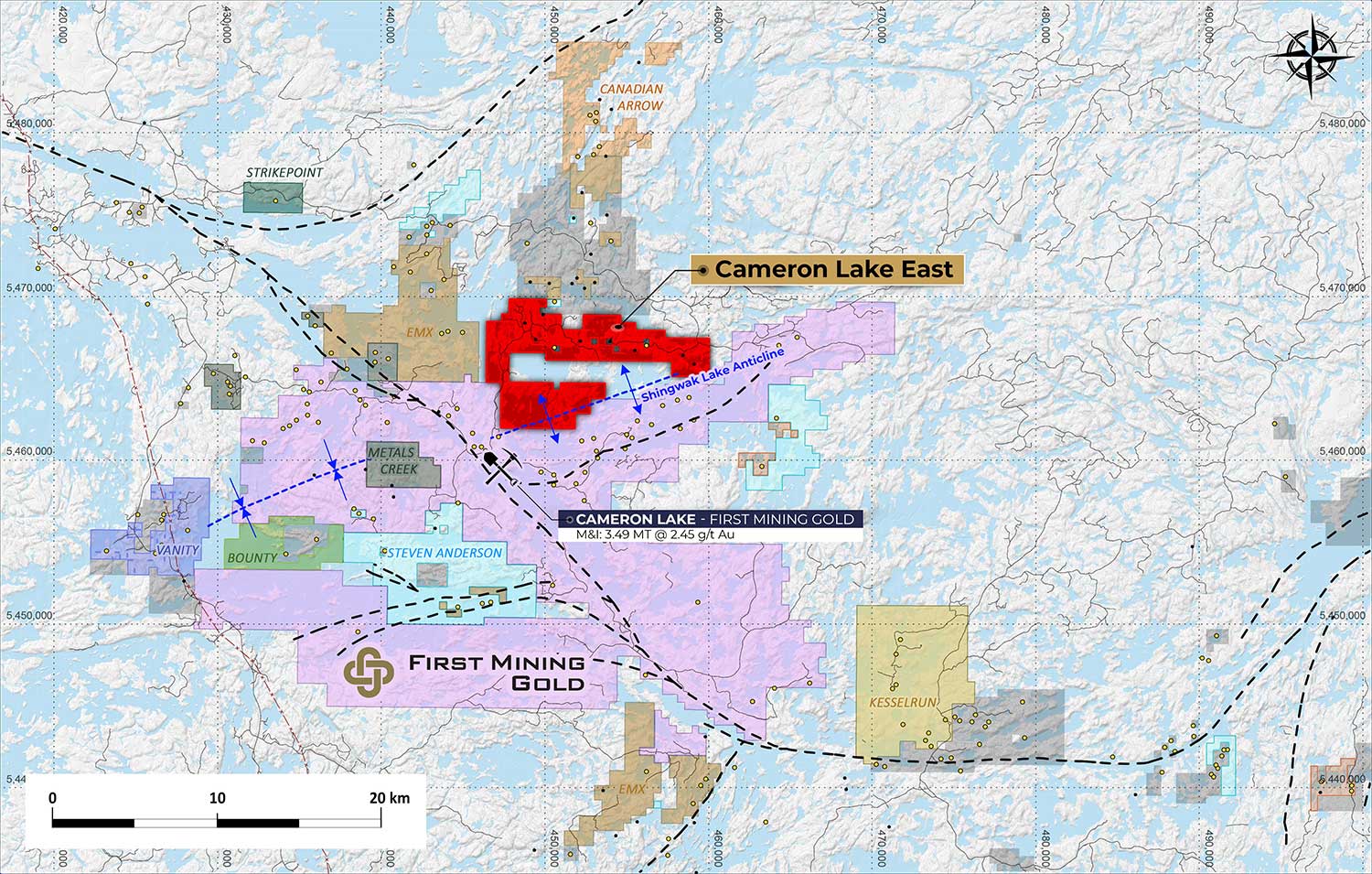
Cameron Lake East
The Cameron Lake East Project consists of 18 mineral claims covering an area of 11,184 acres, approximately 75 km southeast of the town of Kenora in the Kenora Mining Division, Ontario. mineralization along strike of the operating Ming Mine, and on numerous adjacent mineralized trends.
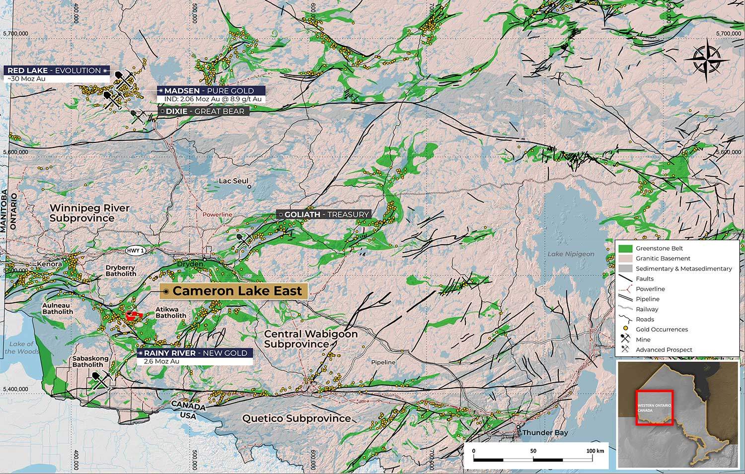
The Property is located at the western end of the Late Archean Savant Lake‐Crow Lake Belt in the Western Wabigoon Subprovince of the Superior Province in northwestern Ontario. The Wabigoon Subprovince is a 900 km long, east‐west trending, composite volcanic and plutonic terrane comprising distinct eastern and western domains separated by rocks of Mesoarchean age. Rocks of the Western Wabigoon Subprovince separate gneissic terranes of the Quetico Subprovince to the south and greenstones of the English River Subprovince to the north.
18
Contiguous single-cell & multi-cell mining claims
4,660
4,660
Total Ha
(11515 acres)
Summary
In the 1950s, modern exploration efforts began, involving various activities like prospecting, mapping, sampling, and surveys. The Cameron Lake East Property is accessible via Cameron Road or Maybrun Road, both requiring travel permits from the Ministry of National Resources. The closest community is Sioux Narrows, serving as a potential source of equipment and personnel. Highway 71 connects the area to Fort Frances and Highway 17, with rail options nearby. The property’s landscape reflects the Canadian Precambrian Shield, featuring glacial terrain and fault structures. The climate is continental, with moderate precipitation and temperature ranges. The region’s vegetation consists of mixed forest, cedar swamps, and bogs. The property holds lakes covering 40% of the area, and land holdings are sufficient for exploration and potential mining infrastructure development.
Geology
The Cameron Lake East project is located in northwestern Ontario’s western Wabigoon Subprovince. This region is composed of volcanic and plutonic terranes, divided into eastern and western domains by age. The accretion of the Western Wabigoon terrane during Neoarchean collision events produced late tectonic intrusions overlying late tectonic sediments and orogenic gold mineralization. In general, Western Wabigoon stratigraphy consists of a lower tholeiitic basalt-dominated assemblage and an upper calc-alkaline mafic to felsic flow and volcaniclastic assemblage. Several regional scale fault arrays transect the terrane, often adjacent to remnants of late tectonic sedimentary assemblages. Outcrop exposure varies, with the highest density of outcrop most visible along lakeshores and islands and is often correlated to differential weather in lithological units.
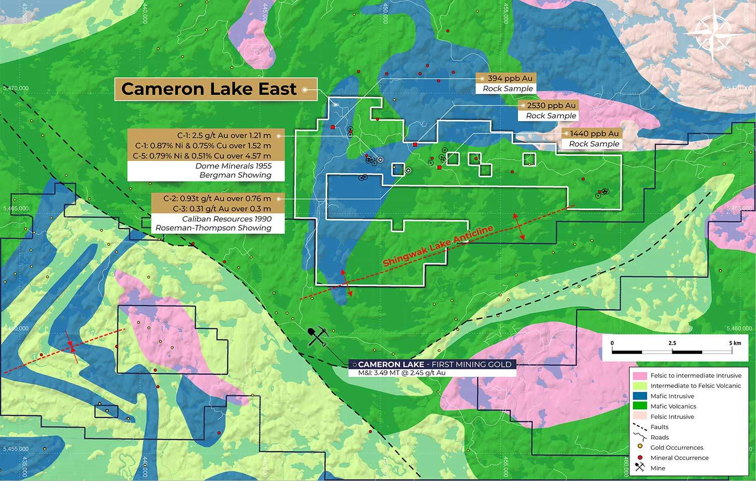
The Cameron Lake East property, within the Rowan Lake Greenstone Belt, is dominated by mafic Rowan Lake Volcanics and mafic to ultramafic intrusive rocks as well as intermediate pyroclastic volcanics. Gold, nickel, and copper mineralization is structure controlled and is associated with contacts between mafic and ultramafic rocks. The major structural feature on the property, The Shingwak Lake anticline, folds the volcanic stratigraphy.
We use cookies to ensure that we give you the best experience on our website. If you continue to use this site we will assume that you are happy with it.